Monday, November 28, 2011

MacLehose Section 1 & 2

(Updated 2020-DEC-19)
Duration: 
(24.1 kilometers)
Section 1: Between 2 and 3 hours depending on walking speed (took us 2)
Section 2: Between 3.5 and 5 hours, depending on walking speed (took us 3.5)

Difficulty: 
7/10. Section one is a road, 90% flat. Really easy. Section 2 has some more challenging hills. About 300 meters ascent. 30% shaded.

Cel phone coverage: No.

Water needs: 2 liters.

Appreciation: 10/10. The views are incredible, especially in Section 2. Long Ke beach really, really nice.

Map & Details: 
https://www.hiking.gov.hk/trail/info/id/VFFUbFFNOXNXTHNWU2FqT09UTjlOZz09/map_type/1#route_map
https://www.hiking.gov.hk/trail/info/id/d0pFSWc1N1dWdkh3aStSajBvUHlmUT09/map_type/1#route_map

Exercise Area: No

Transportation: From Diamond Hill MTR station, KMB 96R will take you directly to Tai Mong Tsai Road where you get off at Pak Tam Chung stop (Sundays and Public holidays only). Otherwise, you can take bus 92 to Sai Kung, then 94 to Pak Tam Chung stop. Return is even easier as section 2 ends almost right in front of a 94/96R bus stop.

Why it's worth it: 


-------------

96R at Diamong Hill MTR station. Very busy on Sunday mornings!


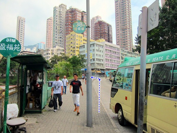
Pak Tam Chung stop bus stop.

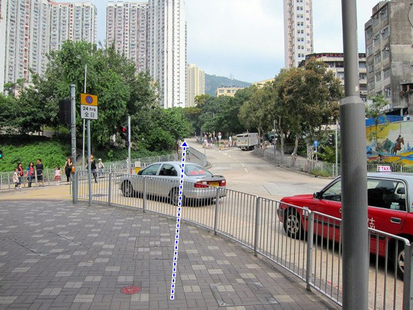
Walk about 100 meters and head right. That's MacLeohose's trail head.
Click for larger version. All the spots marked with a number are referenced in the photos that follow.

Just follow the road. With nice vistas on your right...

... and on your left.

Not very complicated but just in case...
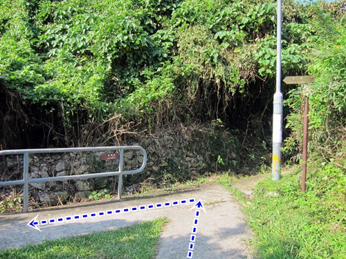
Head left.

Ain't that beautiful?

Right after the principal dam and the pavilion, you'll head left and start climbing.
At this point, you have cleared MacLehose Section 1. Go checkout the dam however, worth a few extra steps.

After 20 minutes or so of climbing up and down, you'll reach Long Ke beach which is  paradisaical and  nicely shaded, making it a nice spot for pic-nics or even camping if you're into it. Once you're done, follow the trail, more climbing and awesome vistas as per photo (Long Ke)


After the 300 meters climb, you'll start going downhill and eventually reach the merging point with the trail that most Sunday hikers take coming from Sai Kung (it is much easier). Head right.

Arriving in Sai Wan village.

Food break or keep going.

Sai Wan beach. The next bit has no shades so it is a bit painful if you do it in the summer and mid-day. 

After 30-40 minutes and a few "wow" moments, you will have reached Ham Tin Wan where you can rest a bit, have some food, restock your water supply and enjoy the beach.
Once you are done, go right through the store and take a left.


After this point, it's all quite obvious; just follow the trail. It is not a steep climb but it keeps going up for about 50 minutes with not much in terms of nice views as rewards for a job well done. 

At this point, don't go straight, keep on the path. You are about 25 minutes away from Tai Mong Tsai road and the end of Section 2. Once at the road, the bus stop will be on your side of the road and to the left.
Congrats on completion of MacLehose Section 1 & 2. Please note that section 3 starts just across the road, should you be tempted to go on.


Sunday, November 13, 2011

Cheung Chau Island short loop

(Updated 2019-APR-22)
Duration: 
2 hours

Difficulty: 
3/10. Flat and paved.

Cel phone coverage: Full.

Water needs: 0.75 liter

Appreciation: 7/10. Nice relaxing walk

Map & Details: 
Click for full-size map


Exercise Area: No

Transportation: Take Cheung Chau ferry from Pier 5 in Central. Ferry every half hour, alternating between regular (an hour to Cheung Chau) and fast ferry (half and hour).

Why it's worth it: 


-------------
Right off the ferry, go straight, slightly to your right to the main piazza.

On the piazza, head left. You'll go buy restaurants and a few food stalls. Good stuff to be had there but  you came here to walk, right?

After just 2 minutes walk, you'll have crossed to the other side of the island, arriving at Tong Wan Beach.  Go straight and turn right onto the path following the beach front.

Keep going by and around the hotel.

Around the restaurant and to the beach path.

On  the paved beach path. Going up about mid-beach.

Going up the path.

Head left here. There's a small temple nearby, have a quick visit and pay respect to the hiking gods (if there is such a thing)

Head left into the mini great wall. Basically, it's just a fancily paved path with a stone railing.
Nice see views along the way.

At the pavilion, take the path down on the right.

You'll eventually reach a set of stairs. You will want to take the stairs and go up on your right.
But before you do so, you can take 10 minutes and go to the end of the path where you'll get a nice view and some interesting rock formations.

After the stairs, after a short walk up. Go straight .

You'll reach a somewhat out-of-place housing development (complete with a pool) surrounded  by a wall. Follow the wall and turn left at the end (by the electrical box) on Don Bosco Road.

Head left.

Head right. On the left if just some private compound.

You are in sight of Nam Tam Wan and its small beach with a Tin Hau temple.
Don't take the first left, keep going straight.

This one you can go down on your left towards the beach and Tin Hau temple.

The temple by the beach. looks like a private hour. The path is actually on your right, before the temple.
Go have a look at the temple and when ready, go up the path.

Stay on the left there.

Hang right.

Then left...

Follow the main road on the left still.

Stay on the main road (Peak Road), keep right.

You'll eventually reach a pavilion. There's a map there to guide you. But if you take Middle Road down on the right, you can\s really get lost; you'll be back to the pier in 10 minutes.
Sample some of the local food before heading back to Central. 


Sunday, November 6, 2011

Lion Rock (獅子山)

(Updated 2020-JAN-04)
Duration/所需時間: 
About 4 hours total. 1 hour from Wong Tai Sin MTR to trail head (#1). 1 hour from trail head to bottom of Lion Head stairs (#2). 1 hour to Reunification pavilion (#4). One hour back to Wong Tai Sin.
4小時。 從黃大仙地鐵到遠足徑起點 (#1): 1小時。 從遠足徑到獅子山下的階梯(#2: 1小時。 到回歸亭1小時(#4)。回到黃大仙1小時。

Difficulty/難度: 
7/10. Beginner hikers may find it tiring as there are quite steep climbs.
初級遠足者可能會覺得很累,因為有不少梯級。要上獅子頭部也需少量攀爬

Cel phone coverage: Throughout.

Water needs: 1.5 liter

Appreciation/欣賞: 8/10. City views are really nice. 城市景觀非常好


Exercise Area: No

Transportation/交通工具: Get to Won Tai Sin MTR station, Exit B3. Really easy. 黃大仙地鐵站B3出口。 真的很容易

Why it's worth it: 


-------------

Click to zoom
Off of Wong Tai Sin's exit B3. Take a right and go straight forward after the stairs and old ladies selling  Joss sticks. You will reach the mini-bus terminus.
黃大仙B3出口,  右轉. 見到樓梯後及賣香的老太太向前走你便見到小巴總站

Head left when you have reached the terminus and turn again left onto Shatin Pass Road. You'll stay on this road until you reach the trail head. I added a few key pictures along the way for reference.
到小巴總站後轉左再轉左到沙田坳道由沙田坳道可直行到遠足徑起點我加一些關鍵圖片以供參考

Keep going on Shatin pass road.
繼續前往沙田坳道

Yep, still going.
繼續向前

Don't be fooled, you keep going straight through, still Shatin Pass Road.
不要搞錯還要繼續向前仍然是沙田坳道啊

And up you go. Shatin pass road all the way!

繼續向上行! 沙田坳道很長啊!


You will go by a temple on your left (nice and peaceful inside if you have a few minutes), Shatin Pass curves to the right, you follow.
在左邊有一閒寺廟 -法藏寺如果你有幾分鐘的時候可入內享受片刻安靜),沙田坳道行向右彎你就跟着行吧

You'll eventually reach this ornate Chinese arch. Just a few hundred meters to go on Shatin Pass road!
你會到達這個華麗的中國拱門還有幾百米就到遠足徑的起點了!

That is the trail head (marker #1 on the map). If you keep going on Shatin pass for another 20 or so meters, there will be  a store where you can replenish your supplies before starting on the trail. There are washrooms there as well. Once you are ready to go, it will be up hill for the next half-hour.
這是遠足徑的起點地圖上標記1)。 如果你繼續在沙田坳道再行20多米你會見到一個士多可以買些補及用品 那裡也有洗手間你準備好後下半小時就全是上山了

About one hour in (a few hundred meters have mile post M104), marker #2 on my map, you will reach an intersection which offers you to climb to the Lion Rock, or bypass it altogether. Head left and climb up. Otherwise, you'll miss all the nicest views.
大約一小時後, 距離M104有幾百米),在地圖上標記2你會到達一個交叉路口讓你爬上獅子山或者繞過它 向左走向上爬 否則你會錯過最美好的景觀
After about 20 minutes of quite steep climb, you'll reach the first mountain crest (#3). at 495meters. Soak in the view and when ready keep walking on the crest. It may look like the trail stops but it doesn't. Keep going. Just be careful on the way down as it can be slippery. You'll climb the next peak.
爬上大約20分鐘後你會到達第一個在495米的山峰(#3好好欣賞美景後便要準備繼續走往山頂你可能以為遠足徑不見了但不是的 繼續小心行因為路上可能有點滑的 你要向下一個高峰出發


Keep going,. In front of you is the Lion Rock!

繼續行獅子山就在你面前

On the left, you can climb up if you want to say you truly went on top of Lion Rock.  The  trail however, continues on the right. On your way down, keep on eye on the Lion Rock in the back as you may see rock climbers scaling the peak.
如果你真的想爬上獅子頭你可以在左邊爬上去但遠足徑(下山) 是在右邊的 在你下山時回頭看看獅子山你可能會看到攀石者

About another 40 minutes down-hill walk and you will reach the unification pavilion (#4) which is also where the Lion Rock bypass trail joins with yours. This is pretty much the end of the interesting part of the trail (ie when one start making dinner plans!)
下山後大約40分鐘你將到回歸亭(#4),這也是獅子山支路與遠足徑合拼與的地方 這也是今次有趣的遠足的結尾可開始計劃晚餐了!)


Take the first paved trail on the left of the distance/direction post. All the way down. About an hour to Wong Tai Sin now.

沿著距離/方向柱左側的路向下走。 大約一個小時便到黃大仙

There may be a few tempting intersections; stay the course on the paved trail.
沿路會見到幾個十字路口;   繼續留原路走

End of the trail. You are pretty much at the entrance of Lion Rock park. Quite nice I am told. Head left down the road.
遠足快結束了 你就在獅子山公園的入口處向左繼續行

About 50 meters down, take short-cut stairs on you left. You will reach Chuk Yuen Road. Head left on Chuk Yuen.
大概50米左右有捷徑樓梯你將到達竹園路向左走

Chuck Yuen Road.

竹園路

You'll reach at set of lights about 200 meters on Chuk Yuen Road. Cross the street and forward into  Ma Chai Hang Road. There will be a park on your left.
在竹園路約二百米處可以到達一盞交通燈 過馬路便是馬仔坑道 左邊會有一個公園

Keep on the sidewalk. After the roundabout, the road becomes Wong Tai Sin Road. Keep going.
繼續在人行道上 迴旋處後便是黃大仙道 繼續行

You'll reach a set of lights on Wong Tai Sin road and across, the road, you'll see a pink gate (Upper Wong Tai Sin Estate). Cross the street, go through the gate and down to estate's piazza. Go right through the estate. There are MTR signs for you to follow. Get into the shopping plaza and there will be further MTR signage. You'll be back to exit B3.
在黃大仙道會見到一盞交通燈在對面你會看到一個粉紅色的門黃大仙上邨)。 過馬路穿過大門到達的廣場, 便有地鐵標誌 進入商場會有進一步的地鐵指示牌 你會回到B3出口

Hike Hong Kong Web Site

HikeHongKOng on Facebook

Please, don't litter!

Hiking is about communion with nature. So please pickup after yourself. There's no excuse to leave plastic bags, water bottles or any rubbish on or around the trails; if you managed to bring it, you can manage to bring it back!